Chapter 11. Tidal Marshes

Tidal Marshes Are at Risk Due to Sea Level Rise, a Threat Compounded by the Impacts of Centuries of Human Use and Modification

Collaborative Restoration Initiatives to Put Tidal Marshes on a More Resilient Trajectory Are Underway Around the Bay

At a Glance

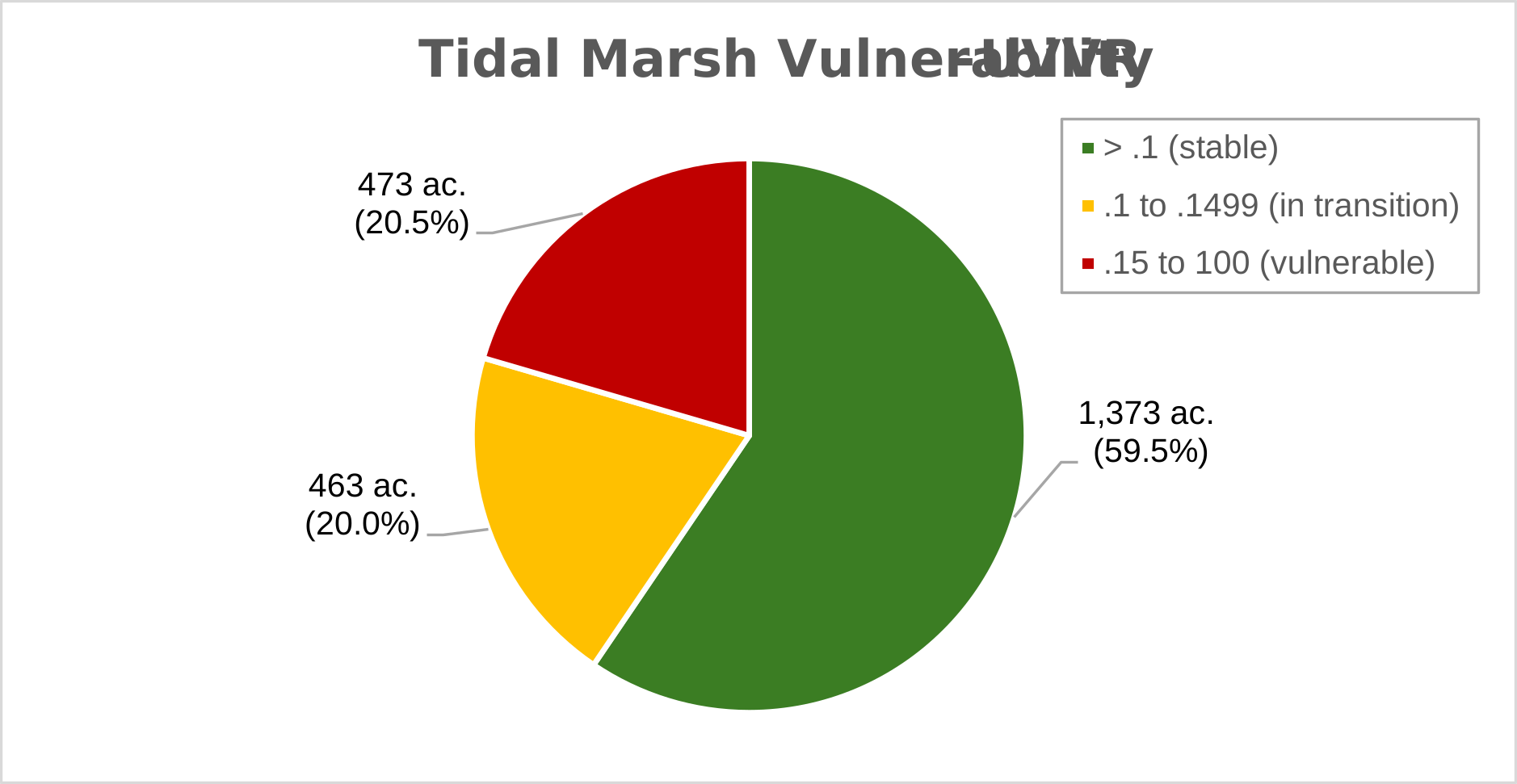
One fifth of the Bay’s tidal marshes are vulnerable to conversion to open water/mudflat based on recent USGS analysis of the ratio of vegetated to unvegetated area of marsh surface. Most marshes are vulnerable over the long-term, without intervention.

Although more data is needed, an initial review of Gamble Marsh data suggests that the average annual elevation gain is outpacing the long-term rate of sea level rise in Portland.

To address this vulnerability, several local partnerships have formed around the Bay to take proactive measures to build marsh resilience through restoration activities.

Since the 2021 Report

Since the 2021 report, there is increased capacity for restoration work in Casco Bay, particularly through collaboration across multiple organizations with shared goals. Dozens of conservation organizations, agencies, and municipalities are focused on the resilience of tidal ecosystems including marshes, mudflats, shellfish, and eelgrass beds. Robust collaborations have helped make large-scale restoration across multiple sites possible.

The integrity of Casco Bay’s ecosystems depends on the function and persistence of coastal habitats that serve as critical habitat for fish, shellfish, birds, plants, and other organisms. These habitats also help protect human communities from flooding, storms, pollution, and the effects of climate change. Within the Casco Bay Plan, there is a particular focus on building resilience in the Bay’s tidal marshes.

Tidal marshes are expansive meadows that exist in sheltered areas that are regularly flooded by the ebb and flow of the tides. They support coastal ecosystems by harboring juvenile fish, enhancing water quality, and providing organic material that supports nearshore food webs and shellfish beds. Tidal marshes buffer coastal communities from storm surge and sea level rise, and they sequester atmospheric carbon and slow the buildup of atmospheric carbon dioxide. Conversely, loss of tidal marsh can release large quantities of carbon dioxide stored in tidal marsh sediments.
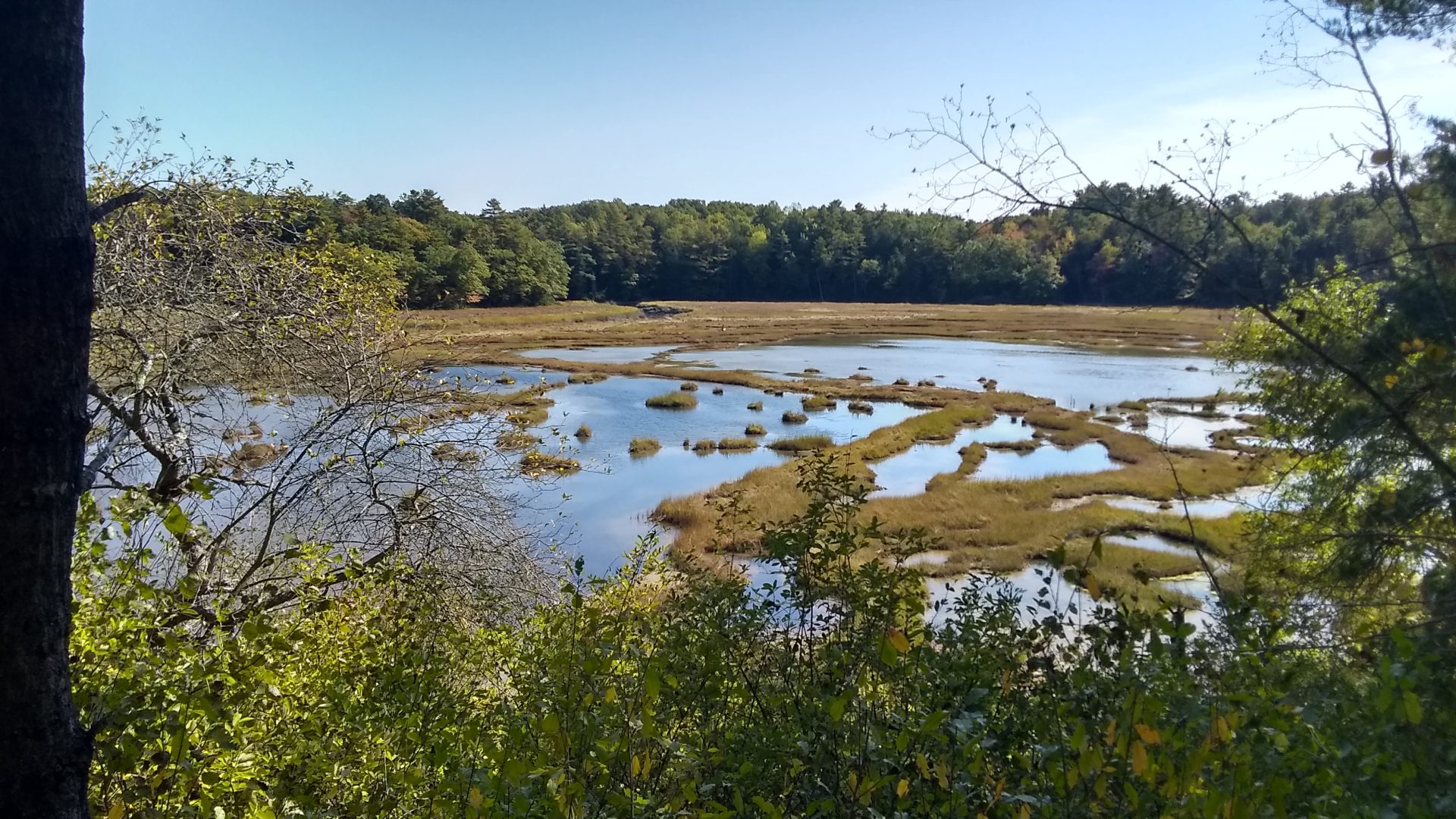
The Cousins River Collaborative is restoring normal tidal flooding and draining processes in the megapool complex at Freeport Conservation Trust’s Walsh Preserve. (Photo Matt Craig, CBEP)

The Impact of Farming and Other Historic Alterations on Tidal Marshes

Tidal marshes continue to be impacted by the historic legacy of farming and other hydrological alterations. European settlers constructed networks of ditches, embankments, trunks, dikes, and other structures on salt marshes to redirect and limit the flow of saltwater so they could grow agricultural products and in some places, graze livestock on the marsh itself. Those farming practices have been abandoned, but the remnant agricultural  infrastructure is now causing rapid expansion of water and bare areas across the marsh surface referred to as “megapools”. Those historical alterations are also contributing to broad losses in elevation, threatening the ability of altered marshes to keep pace with sea level rise.

Many tidal marshes were also dammed to power tide mills or support ice production. Dams on rivers and streams, as well as hardened shorelines adjacent to clay and sand bluffs, interrupt the flow of sediments needed to form and maintain tidal marshes and flats.  Similarly, road and railroad crossings alter marsh hydrology by limiting tidal exchange and drainage of floodwaters.

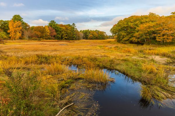
Tidal creek and salt marsh near Marquoit Bay and Wharton Point in Brunswick, Maine. (Photo: Jerry Monkman)

Fringing marsh around Back Cove (Photo: Ecophotography)

Other Challenges to Tidal Marsh Health

Figure 1. Vulnerability of Casco Bay tidal marsh based on the ratio of vegetated to unvegetated area.

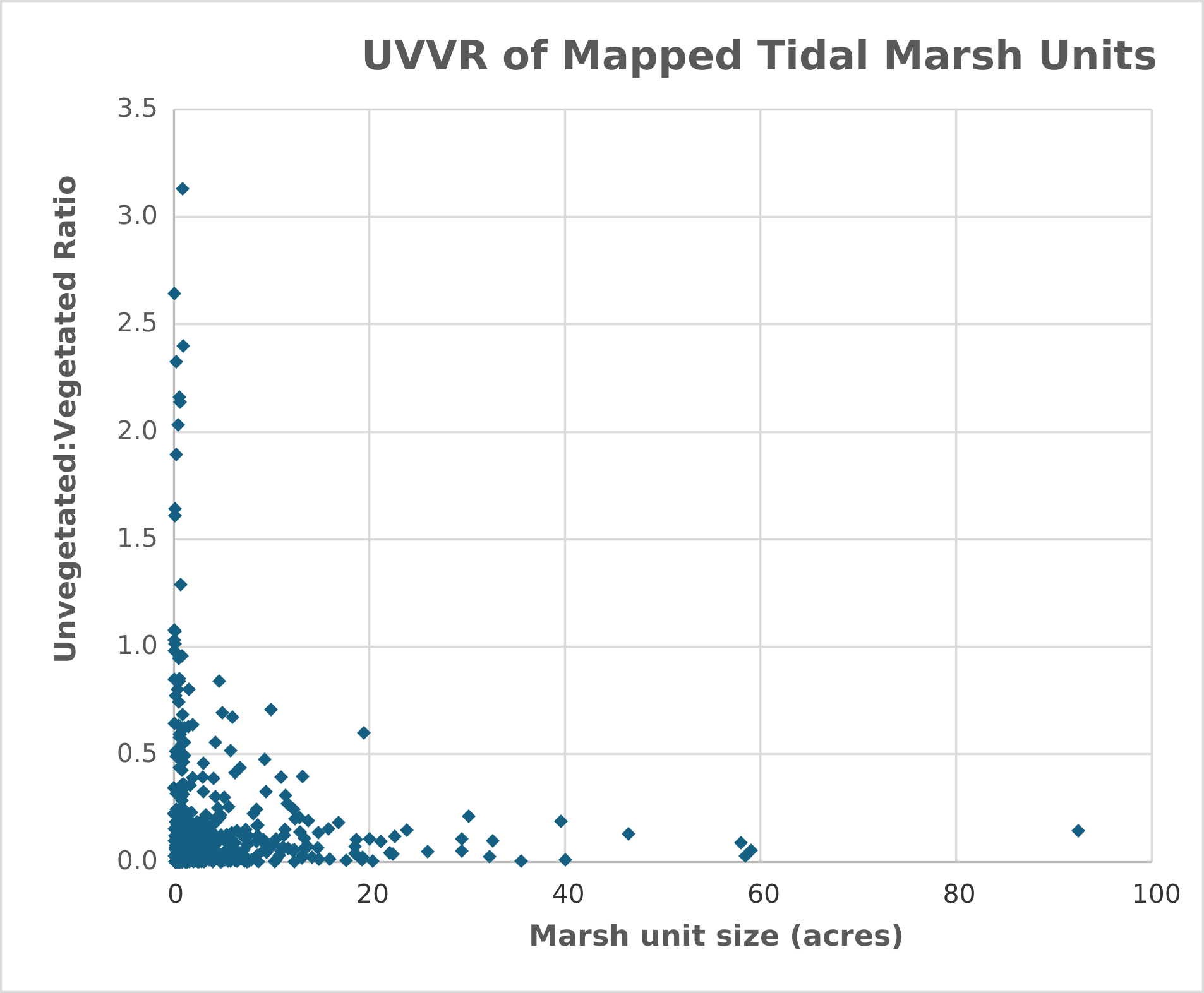
Figure 2. Distribution of mapped tidal marsh units in Casco Bay according to their area and UVVR.


Present day human activities, such as land development, stormwater runoff and nutrient pollution can degrade tidal marshes, contributing to expansion of invasive Phragmites australis and other plant species of concern. Additionally, many of Maine’s tidal marshes are divided into small parcels owned by a wide range of private landowners, municipalities, and conservation organizations. This complicates restoration activities and leads to significant time spent on developing projects with individual landowners.

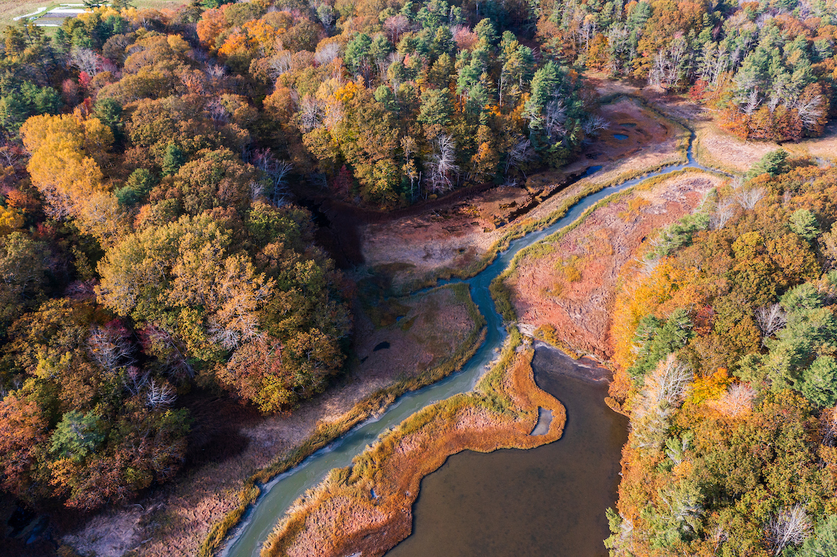
Tidal creek, forest, and marsh adjacent to Middle Bay Cove  in Brunswick, Maine.
Photo by Jerry Monkman

Climate Change Puts Tidal Marshes at Risk

Tidal marshes are at risk due to accelerating sea level rise, a threat compounded by the impact of centuries of human use and modification. Sea level rise and coastal flooding are causing shifts in vegetation, especially in marshes already degraded by other activities.

Collectively, these hydromodifications result in conversion of salt marsh to freshwater or brackish wetlands, colonization by invasive plants, or permanent loss of marsh area. Species dependent on salt marshes, such as saltmarsh sparrow (Ammospiza caudacuta), which nests in high marsh habitats, are imperiled by these cumulative impacts.

Marsh Remediation Efforts Underway by CBEP and Partners

Remediation of impaired hydrology can put marshes on a more resilient trajectory. Restoration activities such as runnelling, ditch remediation, and thin-layer sediment deposition are emerging in Maine as effective interventions.

CBEP is working with partners to remediate historic ditching and diking,replace undersized culverts, and remove coastal dams or dikes (following CoastWise best practices) to restore tidal functioning in these settings. These practices can increase aquatic connectivity and sediment transport, restore marsh habitat, and foster the capacity of tidal marshes to adapt as sea levels rise.

The largest marsh in Casco Bay, which is identified by the Atlantic Coast Joint Venture as important for Saltmarsh Sparrow, is a current tidal marsh restoration focus area. The Cousins River Marsh Collaborative is a science-based partnership dedicated to conserving the Cousins River watershed by protecting land, restoring tidal marshes, enhancing wildlife habitat, and working with local towns and landowners. Through grant writing, resource sharing, and whole-ecosystem restoration, the group aims to build a resilient Cousins Marsh ecosystem that can withstand climate change and rising sea levels.  Phased implementation of marsh surface hydrology restoration began in 2026 thanks to successful grant writing and organizational collaboration between U.S. Fish & Wildlife Gulf of Maine Coastal Program, Maine Coast Heritage Trust, Freeport Conservation Trust, the University of Massachusetts Amherst, CBEP, and other organizations. Research and monitoring results are being shared to inform regional restoration activities.

*Perch to replace with better map

Figure 3. Active tidal marsh restoration projects in Casco Bay.

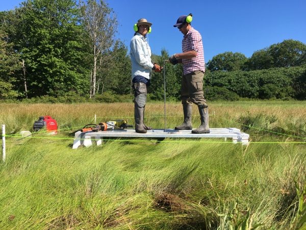
Figure 4. CBEP intern Tristan Taber (left) and Slade Moore of the Maine Coastal Program installing an rSET at Gamble Marsh in Brunswick. (Photo:  Matt Craig, CBEP, 2017)


Sea Level Rise Poses Long-Term Concern

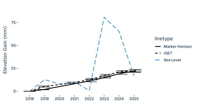
Figure 5. Comparison of mean sea level (Portland) with marsh surface elevation at the Gamble Marsh in Brunswick, at the head of Maquoit Bay.

Scientists are concerned about the future ability of tidal marshes to keep pace with sea level rise.

One long-term monitoring station has been established in Casco Bay, at Gamble Marsh in Brunswick. There, the Maine Natural Area Program uses a network of rod-surface elevation tables (rSETs) to accurately measure precise elevations over time. Initial review of rSET data compared with Portland Tide Station trends suggests that average elevation gain at Gamble Marsh (3.11 +/- 0.24 mm/year; based on rSET data) is so far outpacing the long-term rate of SLR (1.98 +/- 0.13 mm/year; see Climate Change chapter). Elevation gain appears to be mostly due to sediment accretion.

LOOKING AHEAD TO 2030

The expansion of megapools on the marsh surface will only accelerate without rapid and widespread intervention due to anthropogenic sea level rise compounded by natural cycles in the alignment between the earth, sun, and moon. The current 18.6 year Metonic tide cycle transitioned from its low point in 2024 and is currently building toward a multi-year peak, with increasingly higher and frequent high tide heights until 2036. Restoration practitioners consider this decade as critical for the long-term resilience of tidal marsh ecosystems. CBEP plans to continue working with partners to fund and implement restoration projects aimed at building resilience in the Bay’s tidal marshes.