Chapter 6. Streams

Stream Conditions are Linked to Development

Tributaries of the Presumpscot River and Urban Streams Have Persistent Water Quality Challenges

At a Glance

Water quality is good in the majority of the Presumpscot River, but its tributaries have frequent water quality issues.

Urban development, impervious surface cover, and stormwater runoff are linked to degraded water quality.

Low dissolved oxygen and degraded macroinvertebrate communities are the most common reasons that streams in the watershed are listed as having poor water quality.

Since the 2021 Report

Stream conditions are generally similar to what we have seen in the past. Water quality in the Presumpscot River and its tributaries shows no clear signs of declines or improvements, and macroinvertebrate communities continue to be impaired in urban streams. More data on water quality in tributaries to the Presumpscot is becoming available, helping us understand how they influence conditions in the mainstem.

The health of Casco Bay is intrinsically linked to the health of its watershed. Streams and lakes from the coast into the uppermost reaches of the watershed are hydrologically and ecologically connected to the Bay.

Inland waters, including diverse stream, riparian, and wetland habitats, provide recreational and wildlife benefits but they can also transport pollutants, chemicals, and excess nutrients to the Bay. Degraded water quality reduces the biodiversity and populations of aquatic species including insects, crayfish, freshwater mussels, and fish. Migratory fish, such as river herring, rainbow smelt,  and American eels, rely on healthy and unblocked waterways to travel between Casco Bay and rivers and lakes.
How Water Quality is Determined: DEP Classification of Lakes, Rivers, and Streams

Under Maine law, every body of water must meet water quality criteria, specific to the “designated uses” associated with the waterbody’s assigned water quality class. DEP uses data on stream habitat, water quality parameters (temperature, dissolved oxygen, bacteria, chlorides), and biological data (macroinvertebrates and algae) to determine whether a stream meets Class A (best), B, or C requirements, or is in “non-attainment” (not meeting even Class C standards).

For example, lakes, rivers, and streams must have sufficient dissolved oxygen to support healthy insect and fish communities. Waters that do not meet related standards are labelled as “impaired”. Information on water quality classes and impairments is shared through DEP’s biennial Integrated Water Quality Monitoring and Assessment Reports.

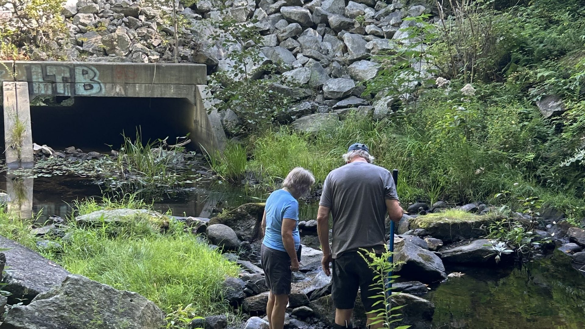
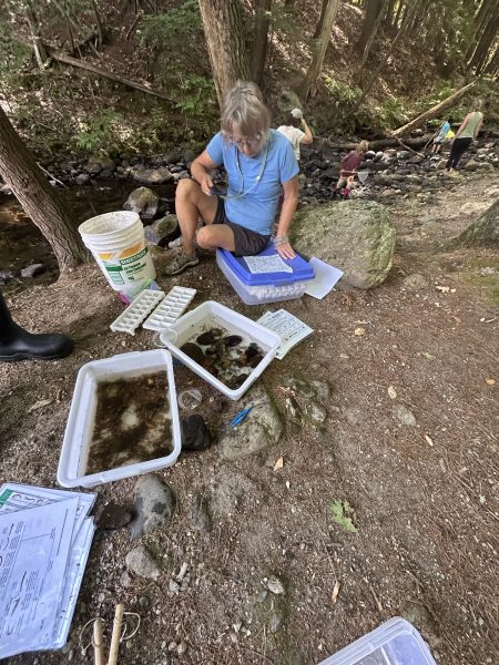
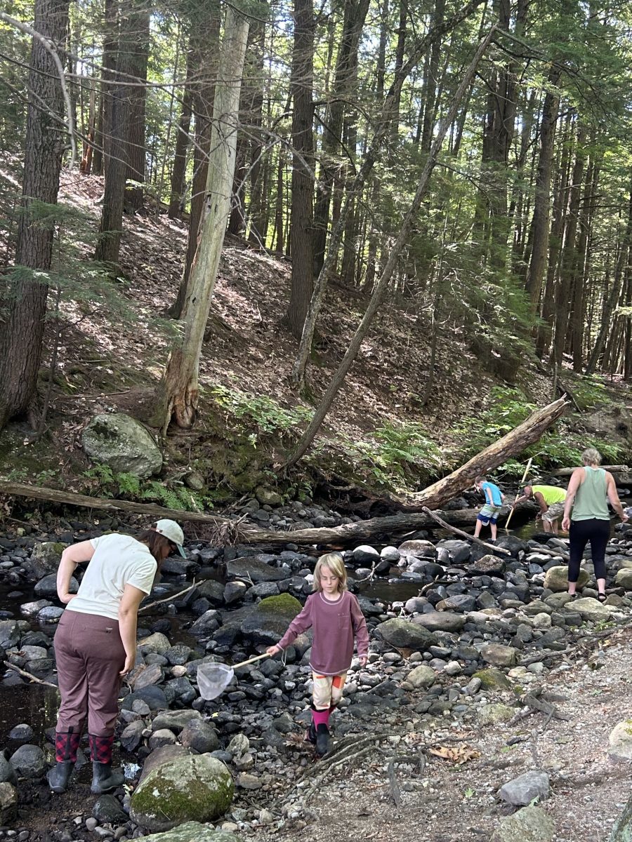
Volunteers sample Mill Brook Creek. (Image: Clara Franzoni, PRLT)


IMG_6291
Volunteers sample Mill Brook Creek. (Image: Clara Franzoni, PRLT)

Volunteers  Conduct the Majority of Monitoring

Presumpscot Regional Land Trust (PRLT) leads a group of volunteers in monitoring the water quality of the Presumpscot River and its tributaries with support from Maine DEP’s Volunteer River Monitoring Program (VRMP). As of 2024, PRLT monitors 12 locations on the mainstem Presumpscot and 32 locations on the tributaries. Data records at some of these sites go as far back as 2009.

Lieft: Volunteers sample Mill Brook Creek. (Image: Clara Franzoni, PRLT)

Site Evaluations: Water Quality Results in Detail

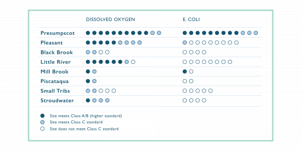
We evaluated sites as meeting Class A/B or meeting Class C water quality standards. Class A and B standards are identical for the analyses we did, so we did not separate them. All mainstem sites met Class A/B dissolved oxygen standards at least 90% of the time, and most tributary sites met either Class A/B or Class C dissolved oxygen standards at least 90% of the time. Elevated levels of bacteria were much more common, with most tributary samples frequently failing to meet Class C standards.


Downstream Sites Had Higher Incidence of Contamination

Mainstem sites had lower bacterial levels as the clean water coming from Sebago Lake dilutes bacterial contamination from tributaries. Further downstream sites showed signs of increased contamination (only meeting Class C instead of Class A/B standards) as the combined influence of tributaries grows.

Conditions in the mainstem river and tributaries vary from year to year but are not generally showing either long-term improvement or deterioration of conditions. The only exceptions are slight trends of increasing bacteria levels in the uppermost site of the Presumpscot River and decreasing bacteria levels in parts of the Pleasant River.

IMG_6295
Volunteers sample Mill Brook Creek. (Image: Clara Franzoni, PRLT)

The Effect of Urbanization on Water Quality

Streams in urbanized areas with high amounts of impervious surfaces (roofs, parking lots, roads, etc.) frequently fail to attain their stated water quality class. Urbanized streams suffer many stresses that can cause altered hydrology, degraded habitat, impaired macroinvertebrate communities, higher temperatures, lower dissolved oxygen, and elevated levels of toxic contaminants. Stormwater, or the runoff that occurs during and shortly after storm events, is a main driver of this stress.

Impervious surfaces like roads, parking areas and rooftops,  prevent rainfall from soaking into the ground. Instead, that water moves over the ground as runoff.  Increased runoff and reduced groundwater increase stream flow after rains but lower flow between storms. Stormwater runoff is generally fast flowing, increasing flood risk and erosion. Summer water temperatures increase because of reduced contributions of cooler groundwater to the stream, greater warming of shallow waters, and because stormwater can be heated by running over hot pavement.

Runoff across impervious surfaces picks up toxic metals, petroleum products, pesticides, and other contaminants as it moves and carries them to downstream waters. Chloride contamination of freshwaters from winter deicing salt (see Emerging Data chapter) has been linked to impaired stream macroinvertebrate communities.

Long Creek Demonstrates Impacts of Stormwater

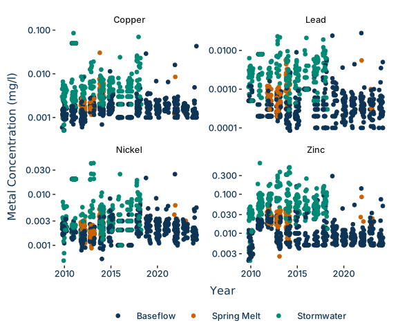
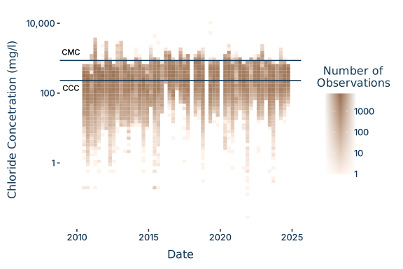
Long Creek is an urban stream with a highly developed watershed that clearly demonstrates the impacts of stormwater. Metal concentrations in the stream are generally low and infrequently exceed state criteria, but consistently spike after stormwater events.  Chloride levels in areas below commercial areas with extensive road and parking areas regularly exceed levels of concern.  Since 2010, more than 50% of calculated chloride values at six long-term monitoring sites have exceeded levels of concern, while at the most downstream location, more than 80% did.

Metal Concentrations in Long Creek:  Metal concentrations during baseflow, spring melt, and rain events. Note that storm flows have not been sampled since 2018. Metal concentrations that exceed levels of concern are rare except for copper and zinc following rain events.

Chloride Concentrations in Long Creek. Concentration above the “Criterion Maximum Concentration” (CMC) which have the potential to harm freshwater organisms with even short exposures are observed in Long Creek occasionally every year, but levels above the “Criterion Continuous Concentration” (CCC), which can harm aquatic life only after a longer period occur regularly, especially at downstream locations.

Looking Ahead to 2030

Monitoring of inland waters could be improved by higher frequency data collection. While existing monitoring–most of it conducted by volunteers–provides a solid baseline, results can be heavily impacted by when monitoring occurs in relation to events like heatwaves or heavy precipitation.

Costs of automated “continuous” data collection have dropped in recent years, making data collection more affordable but creating new challenges. Novel methods offer new insight into the health of our fresh waters, but managing and interpreting the resulting flood of data demands greater skill from data managers, analysts, and science communicators. Organizations including Presumpscot Regional Land Trust have begun to deploy continuous monitoring equipment.

There are also efforts underway to expand collection of nutrient and chloride data in freshwater streams. Nutrient data will provide information on sources of pollution like fertilizers and wastewater and how to better manage them. Chloride data from more locations will help towns  and private landowners reduce use of winter deicing salt while protecting public safety.